
The role of Fluids in Fault Movement, Mormon Mountains, Nevada
Abstract
The Mormon Peak Detachment (MPD) is a Miocene-aged low-angle normal fault, or set of normal faults, that accommodated movement of upper-plate Paleozoic carbonate rocks downslope over lower-plate Paleozoic carbonates and Precambrian metamorphic rocks. The MPD is characterized by several features that are typical of faults that lie at the base of large block slides and not typical of tectonic faults that cut through the crust. Furthermore, the geometry of the MPD is much more consistent with a block slide than a throughgoing tectonic fault. Fluid inclusion homogenization temperatures from calcite veins associated with the MPD range from 70 to 130 C, very similar to the range temperatures obtained from clumped isotopes (“trapping”, or true temperatures) from calcite in “syn-faulting” calcite veins. The similarity of homogenization temperature to trapping temperature points to an absence of a fluid inclusion temperature correction due to pressure (the so-called “pressure correction”), and thus precludes significant fluid pressures during vein filling, hence during faulting. Low fluid pressures mean two things in terms of the MPD: 1) the fault lay at shallow depth during movement, probably less than a few hundred meters; this depth is much less than the 2 – 4 km depths required by models that posit the MPD as a tectonic fault, and 2) elevated fluid pressures (overpressures) were not important in the mechanics of movement on this fault, which dips at low angle (~10 degrees or less). Elevated temperature at shallow depth may have resulted from frictional heating during block sliding. Fluids clearly were present in the fault during movement, as indicated by the syn-fault calcite veins as well as hangingwall clastic dikes, but movement was facilitated by processes other than fluid pressure.
Introduction
The purpose of this project is to evaluate the involvement of fluids in the movement of a large fault exposed in the Mormon Mountains, Nevada. This particular fault is well-exposed in three dimensions and moved while at a low angle to the horizontal. The fault serves as a natural laboratory for studying the involvement of water in the movement of rock on gently-sloping surfaces that may not have experienced movement if water were not present.
The prediction of earthquakes in a short enough time window to allow for orderly evacuation, thus preventing massive loss of life, is one of the most challenging problems in Geology today. Such prediction requires an accurate understanding of the processes that cause earthquakes. The broken-up rock of a fault zone tends to be more permeable than the unfaulted rock it cuts through, and so can act as a channelway for water or other fluids. Water (for example, groundwater) in a fault is known to influence earthquake genesis by lowering the effective stress that essentially holds the faulted blocks of rock together (the ‘normal stress’), thus reducing frictional resistance to movement. The higher the water pressure relative to the force holding the rocks on the two sides of the fault together, the greater the water’s effect on reducing frictional resistance and thus the more it triggers earthquakes. Water also reacts chemically with minerals in the fault, commonly forming new minerals such as clays that have lower frictional resistance to movement or dissolving and reprecipitating minerals in such a way as to aid movement along a fault. In these ways, water can strongly influence the earthquake process. Water is thus important to understand in any accurate model of earthquake occurrence, which in turn underlies any mechanical model for prediction.
The Mormon Mountains are an excellent place to study the nature of fluid flow in a fault: the fault (the Mormon Peak Detachment) and adjacent rocks are well-exposed in three dimensions, and the low angle of the fault (a few degrees to the horizontal) practically requires the involvement of a fluid (or, if not, an extraordinary process) for movement to occur. The mountains are also well-studied geologically, but as it turns out, the geology of the Mormon Peak Detachment is highly controversial. This controversy bears on the understanding of how water behaves in the fault, and so is briefly reviewed here. Wernicke et al (1985), Taylor (1984), Skelly (1987), Axen et al. (1990), and Swanson et al (2012) maintain that the Mormon Peak Detachment cuts through the entire crust (approximately 25-30 km thick) and has been the site of tens of kilometers of movement of rocks on one side of the fault relative to rocks on the other side. They based their interpretation on several observations: 1) The rocks beneath the fault (the footwall) originally lay deeper beneath the surface prior to faulting the farther west one goes in the range. Similarly, rocks that are now above the fault (the hangingwall) originally lay at greater depths beneath the surface the farther one goes to the west in the range. This suggests that the fault itself dips (is tilted) to the west and that the hangingwall rocks moved uniformly down to the west. They propose that the now-exposed fault lay at depths between 2 and 8 kilometers while it was active. 2) The orientations of minor faults in the hangingwall rocks are broadly compatible with movement to the west. 3) The mountains are in a region that has undergone considerable extension at the same time the Mormon Peak Detachment moved, between 15 and 20 million years ago.
In contrast, Carpenter and Carpenter (1994), Walker et al (2006), Anders et al. (2008), and Anders et al. (2013) interpret the same fault as underlying several large blocks of rock, some several km on a side and over a hundred meters thick, that simply slid independently of one another for a few hundred meters to perhaps a few kilometers down the flanks of the range. They base their interpretation on several observations: 1) The blocks of hangingwall rocks are scattered across the range. The fault beneath each block contains indicators (called kinematic indicators, such as linear features known as slickenlines) that line up with the downslope direction on the fault plane (that is, the downdip direction) at that particular location (e.g., Walker et al., 2007) and that all point back “uphill” toward a location in the central Mormon Mountains near the present-day topographic high point of the range; the blocks have not all moved uniformly toward the west as indicated by Wernicke and others. 2) The Mormon Peak Detachment exposures contains features that are consistent with landslides elsewhere in the western US and not with generally-acknowledged faults that cut through the Earth’s crust and that were active over a long period of time. Most importantly, the rocks immediately beneath the detachment show a very low density of microfractures (cracks that require a microscope to see), consistent with a single movement event (Anders et al., 2013). In contrast, known crust-cutting faults (aka tectonic faults) are contained within rocks that have a very high density of microfractures, formed as a result of repeated brittle movement episodes (earthquakes) over a long period of time. In addition, nearly all samples of the fault rock itself (a broken-up rock called breccia) contain fragments that have been broken only once (Anders et al., 2013); there is little evidence of multiple episodes of breakage of Mormon Peak Detachment fault breccias. Further, the Mormon Peak Detachment contains widely-distributed conglomerates (rocks made of rounded pebbles and sand) that are not formed in tectonic faults. In the Mormon Peak Detachment, these rocks are commonly stratified in the fault but are clearly not sedimentary; rather, they represent breccias that were fluidized and rounded during fault movement (Anders et al., 2000). Finally, the hangingwall commonly contains clastic dikes, mixtures of sand, gravel and water that were injected upward from the fault into the overlying rock under pressure. These features are common in the upper plates of other known block slides, such as at Heart Mountain, Wyoming (Pierce, 1979); they’re very uncommon in association with tectonic faults that moved at depths of several kilometers beneath the surface. 3) Study of the basins adjacent to the Mormon Mountains, particularly by seismic reflection (by which sound waves are generated at the Earth’s surface by explosives or ‘thumper trucks’, reflect off features beneath the surface and return to the surface where they are detected by devices called geophones) shows that there is no low-angle fault within or beneath the basin. The Mormon Peak Detachment appears to be confined to the Mormon Mountains, which is not compatible with the first model (of Wernicke and collaborators); other bona fide tectonic detachment faults can be imaged by seismic reflection to continue under adjacent basins and even neighboring mountain ranges (e.g., Snake Range Detachment, Hauser et al., 1987).
My interpretation of the role of fluids in movement on the Mormon Peak Detachment is affected by which of the geologic models is correct. Clearly, the fluids had a different role in fault movement if the blocks are rapidly sliding downhill for long distances (over a kilometer) under their own weight rather than episodically moving short distances (up to a few meters at most in the largest earthquakes) in a confined, deeply buried setting. Thus deciding which geologic model accounts for faulting on the Mormon Peak Detachment is of significance to understanding the role of fluids, and comprises part of this project.
Methods of study.
In conjunction with this project as well as in collaboration on an NSF grant, I worked with Brian Wernicke and his grad student Erica Swanson, as well as with isotope geochemist John Eiler (all at CalTech) on a project involving clumped isotope thermometry of rocks associated with the Mormon Peak Detachment; this technique was pioneered by John Eiler (Eiler, 2007). I went into the field with Brian and Erika in October 2010 for two days, an experience that included an automotive mishap (due to bad driving on the part of Brian) and a helicopter rescue. Forty two samples from a range of geologic settings (fault gouge, breccia matrix, upper-plate veins, unfaulted rock, and so on) were collected for isotope analysis from four different sites in the Mormon Mountains. Samples were examined petrographically and by Scanning Electron Microscopy (SEM), as well as by X ray diffraction. Fluid inclusions were sought in several samples but none were found. Previously-collected fluid inclusion data from Losh (1997) are used for comparison to the temperatures determined by the clumped isotope technique. A fluid inclusion yields a homogenization temperature at which the vapor and liquid within the inclusion become a single phase upon heating in a specially-designed microscope stage; this temperature is the lower limit of the actual temperature at which the inclusion was trapped by the mineral as it precipitated from the fluid. The difference between the homogenization temperature and the actual trapping temperature, which can be obtained from several techniques including clumped isotope analysis of the mineral that contains the inclusions, allows an estimate of the pressure of the fluid at the time of trapping of the inclusion. This pressure can be compared with values that would normally be expected at the depth range at which the fault was active in order to determine if the fluid was excessively pressured or not. This information can be used to assess the role of fluid in the faulting process.
I also traveled into the field with two MSU undergraduates in October 2011 to sample two key locations indicated in Anders et al. (2006) and Diehl et al (2010). The Anders et al. site contained excellent exposures of the Mormon Peak Detachment and clastic dikes above it. Diehl’s site consisted of a faulted block in which she proposed large-scale post-faulting dissolution of carbonate rock by groundwater that flowed preferentially along the detachment fault. I returned to the field in June 2012 with Mark Anders for three days to examine and sample sites throughout the range.
To compare the Mormon Peak Detachment with faults that underlie known landslides, I traveled in July 2012 to White Mountain, about 50 km north of Cody, Wyoming, to examine and sample the Heart Mountain Detachment (a nearly flat fault that underlies a 90+-km long by 1 km thick block of rock that moved on the order of 40 km on a fault that was tilted (dipping) only 2 degrees relative to horizontal; Pierce, 1980; Anders et al. 2010). Additionally, I examined and sampled the fault at the base of the Palisades slide, near Irwin, Idaho (Anders, 2012, pers. communication). The fault at the base of this slide separates Paleozoic Gros Ventre limestone in the hangingwall from Quaternary river gravels in the footwall. The slide moved several kilometers from the nearby mountain range front.
Results
1) The preponderance of evidence, in my view, favors the block slide interpretation for the Mormon Peak Detachment. Much of this evidence has been summarized previously in this report; in addition, the topography of the Mormon Mountains and the distribution of exposures of the Mormon Peak Detachment are such that a throughgoing fault of regional extent and on which there has been tens of km of movement is geometrically improbable. Lower-plate rocks on the south flank of the Mormon Mountains at Moapa Peak stand thousands of feet higher than the Mormon Peak Detachment nearby, with no fold or fault between those locations that would accommodate a continuous detachment fault that would have been eroded from above Moapa Peak. The foregoing observations don’t pose a problem to the block slide hypothesis. At the same time, there are some complications to the block slide hypothesis. Anders et al (2006) stated that block slides are characterized by minimal deformation below the detachment fault, and that there is only a single episode of brecciation (breakage of rock into fragments) or vein formation (fracturing followed or accompanied by precipitation of dissolved minerals from a fluid), reflecting the presumed single episode of sliding that the block experienced. These observations apply at the Palisades and White Mountain block slide exposures: there is a remarkable lack of deformation in rocks immediately below the detachment at those locations, and I was able to find only one set of veins at each place. In the Mormon Mountains samples I examined, I observed only a single episode of brecciation in the rocks using cathodoluminescence (Anders et al, submitted). However, the rocks beneath the Mormon Peak detachment are commonly brecciated (broken up) in a zone at least 8 meters thick in places, with the brecciation decreasing in intensity with distance below the detachment, and at least two sets of veins of different ages are present at some locations. Furthermore, at some locations, fault rocks record multiple episodes of brecciation (e.g., Swanson et al., 2012; Diehl et al., 2010). These observations are in fact consistent with the regional tectonic fault model; however, the evidence against the tectonic model is, in my view, strong enough that these apparent contradictions may simply reflect somewhat different and more complex mechanical behavior of the Mormon Peak Detachment as compared to the Heart Mountain and Palisades faults.
A further complication to the Mormon Peak Detachment geology is that the hangingwall sedimentary rock units in the Mormon Mountains are inexplicably thinned by up to 80% relative to their counterparts in nearby mountain ranges or even elsewhere in the Mormon Mountains where they are in the footwall of the Mormon Peak Detachment (Walker, 2008). Extension during faulting typically causes thinning of the hangingwall by block rotation along discrete faults that merge downward with the detachment, but the thickness of the individual units within fault blocks typically remains constant. But in the Mormon Peak Detachment hangingwall, even within a particular fault block in the hangingwall, each individual sedimentary rock unit (aka stratigraphic unit) in the hangingwall is thinned relative to its undeformed thickness, with the extent of thinning increasing with original (pre-faulting) depth beneath the surface. Presently, the upper plate to the Mormon Peak Detachment is at most about 200 meters thick, whereas the original thickness of the sedimentary rock column prior to faulting was about 2 km. Reconstructions by Walker (2008) show that the entire ~200-km2 area of the Mormon Peak Detachment hangingwall (termed the Mormon Peak allochthon) could have originated from a 6.5 km2 block of sedimentary rock at its pre-faulting thickness. The mechanism of this pervasive thinning is not clear: the rocks have not been granulated so that they thinned uniformly as they moved downslope, nor are widespread dissolution features (e.g., caves, collapse breccias, stylolites) abundant in the predominantly carbonate rocks as they should be if the thinning were accomplished by solution by flowing groundwater as proposed by Diehl et al. (2010; caves are locally present, however ).
A final consideration with regard to the Mormon Peak Detachment is whether both explanations could be correct for different parts of the fault’s history. In particular, could the detachment be a tectonic fault that experienced tens of km of movement, and then was reactivated some time later as a zone of weakness along which blocks slid downslope? The evidence for a tectonic affinity of the detachment, however, is largely absent: it is not a regionally-extensive structure, it doesn’t appear to extend beyond the present Mormon Mountains into places where it should be and where it could be detected if it were there. And it is not characterized by the microfracture density that would be expected for a tectonic fault; this density would be preserved in rocks beneath the fault even if it were reactivated.
2) Veins (calcite and/or dolomite) in the field and in thin sections (viewed under a microscope) of rocks from the Mormon Peak Detachment indicate that fluid was present during faulting. This observation is further borne out by oxygen and carbon isotope data, which point to the interaction of groundwater, which was originally rainwater and/or snowmelt (meteoric water), with rocks in the fault zone during faulting. Clastic dikes, which are present but not particularly common in the Mormon Mountains (especially as compared to the Heart Mountain Detachment), also provide evidence of likely involvement of fluid in the form of a slurry of water-saturated (fluidized) sand and pebbles that were injected into rocks above the detachment as the block moved (Anders et al., 2000). Losh (1997), Diehl et al. (2010), and Swanson et al. (2012) all interpret the oxygen isotope data from fault rocks as indicating the presence of meteoric water in the fault. Losh (1997) proposed that this water interacted with varying amounts of rock along its flow paths.
3) The clumped isotope temperatures are shown in Figure 1, along with fluid inclusion homogenization temperatures from Losh (1997). In detail, the clumped isotope temperatures for minerals in equilibrium with fluid in the fault fall into two groups: a ‘cold’ group (~25-40° C) characterized by the latest-formed (crosscutting) veins in a sample and a ‘warm’ group (70 – 130° C) characterized by veins that independent evidence suggests formed at the same time the fault was moving. As indicated, the difference between the temperature at which a fluid inclusion homogenizes and that at which the mineral that contains the inclusion was precipitated from the fluid that was trapped (the trapping temperature) can be used to determine the fluid pressure at the time the inclusion was trapped. Ideally, these two temperatures are determined from the same sample. However, the fluid inclusions in these rocks are few and far between, and the inclusions and the isotope samples from which trapping temperatures are determined are not from the same rocks, preventing a strict comparison of the two temperatures by which fluid pressure could be determined with confidence.
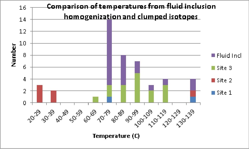
Figure 1. Comparison of fluid inclusion homogenization temperatures from Mormon Peak Detachment (veins within and above the fault) with temperatures of vein deposition determined from clumped oxygen and carbon isotope data reported in Swanson et al. (2012). The three sites are different sampling localities in the Mormon Mountains; the fluid inclusion data actually originate from samples collected at Site 2 (near Mormon Peak). However, no veins were sampled for isotope analysis at Site 2, so the veins from Site 3 (about 5 km distant) were used for the comparison. They come from the same structural position relative to the detachment as the fluid inclusion samples.
Although the data do not allow direct comparisons as they are from different samples from one another, and the frequency of values in the dataset is largely a sampling artifact (and so no statistical significance can be assigned to the slight difference in modes and means between the fluid inclusion temperatures and, say, Area 3 clumped isotope temperatures), there is no significant difference between fluid inclusion and isotope temperatures as shown in Figure 1. If the calcite that hosts fluid inclusions were precipitated at a depth of 2 km (the veins are in the hangingwall, which is known to be at most 2 km thick (i.e., fluid pressure of 200 bars, assuming a hydrostatic pressure gradient) based on the known thickness of the rock units that comprise it), the difference between the homogenization temperatures and the clumped isotope (trapping) temperatures would be in the range of 10-20° C (Bodnar, 2003; with the fluid inclusion temperatures being lower than the isotope temperatures) depending on whether the fluid was at hydrostatic or lithostatic pressure, respectively. In this case, the pressure correction for determining trapping temperature is too small to allow us to distinguish between near-surface pressures and those prevailing at 2 km depth, hence whether the inclusions were trapped in a rooted detachment fault or in the base of a block slide.
At the same time, temperatures indicated by both fluid inclusions and clumped isotopes are much higher than normally expected for a depth of 2 km. Typically, temperature in environments like this increase with depth at a gradient of 25 – 30° C/km; thus, normal temperature at 2 km depth (given a 10° C temperature at the surface) is on the order of 60 – 70° C The ‘cold’ veins appear to have formed late in the history of the fault, after its main movement. The ‘warm’ veins are characterized by temperatures that in most cases exceed the ‘normal’ temperature at 2 km depth by tens of degrees. This elevated temperature, especially in a block sliding environment, implies frictional heating took place as the block moved catastrophically downslope for hundreds to thousands of meters at speeds measured in kilometers per hour rather than at centimeters per year, as is the case with the most-active tectonic faults. At the same time, the block was significantly thinned, either before or (much more probably) during sliding. Substantial frictional heating on the Mormon Peak Detachment is consistent with observations in other block slides and with laboratory experiments It is implicated in the formation of so-called ‘armored grains’ – coarse fragments of breccia rimmed with finely-ground rock that accumulated in the late, cooling stages of high-temperature particle flow in carbonate rocks – observed in the Mormon Peak Detachment breccias (Anders et al, 2006).
As noted, the oxygen isotope data of Losh (1997) and Swanson et al (2012) indicate the involvement of meteoric water (rainwater, snowmelt) in the fault zone. However, much of this meteoric water interacted with carbonate rock along its flow path and so was changed (by exchanging isotopes with the rock) in terms of its isotopic composition prior to precipitating the sampled minerals. Losh (1997) interpreted this exchange as having taken place along a long flow path associated with a tectonic detachment fault that extended tens of km into the Earth and that moved 20+ km, as proposed by Axen et al (1990). Re-evaluation of the fault geology, and consequent reinterpretation of it as a slide block, requires that the isotope data be interpreted in this new context. Two explanations could account for the variation of isotopic composition of the fluid: 1) the groundwater in the rocks that were ultimately incorporated into the fault zone had varying oxygen isotope compositions prior to faulting, and so imparted their heterogeneity to calcite precipitated by them, or 2) water exchanged isotopes with the rock during faulting. Isotope exchange between fluid and rock is carried out by repeated cycles of mineral dissolution and reprecipitation. During faulting, dissolution can be aided by mechanical grinding of rock into small-diameter particles by fault movement (smaller particles dissolve more readily than large ones). It can also result from pressure solution, which promotes dissolution of carbonate minerals at high-stress contacts between mineral grains, for example during faulting. Precipitation can be especially aided by drops in fluid pressure, as carbonate minerals are less soluble in water as pressure decreases (actually, as the pressure of dissolved carbon dioxide decreases). Increases in temperature can also promote carbonate precipitation (carbon dioxide is less soluble in water at higher temperatures); such temperature increase may result from frictional heating accompanying (and aiding) block sliding.
At its extreme, frictional heating of carbonate minerals (to about 800° C) during block sliding (and tectonic faulting to a lesser extent) causes their decomposition to oxides, much like a cement plant roasts limestone in furnaces to produce calcium oxide. This process is known as calcining. The resultant oxide is highly reactive in a water-saturated environment, converting (in the case of Calcium oxide) to calcium hydroxide. Dissolved (bi)carbonate in the water reacts with the hydroxide to re-form calcium carbonate; this process is believed to have taken place in the Heart Mountain Detachment and quite possibly in the Mormon Peak Detachment as well (Anders et al., 2010). This whole process can produce substantial isotope exchange between carbonate minerals and fluid, most notably by liberation, and subsequent dissolution, of substantial amounts of CO2 from the mineral during heating. The oxygen isotopic composition of reprecipitated carbonate minerals reflects this mixing of mineral and water isotope inventories. Thus, there are ample mechanisms in block slides to explain a spread in oxygen and carbon isotope values of fluid in equilibrium with the rock. However, given the wide range of possible calcite precipitation temperatures in rocks that have undergone frictional heating to 800° C, followed by cooling, it isn’t clear why the preponderance of temperatures indicated by both isotopes and fluid inclusions are in such a narrow range, and at the low end of the possible values. It may be that actual calcining in the Mormon Mountains is rare or that conditions favorable for calcite deposition existed only in the late stages of block movement. At this point, no direct evidence for calcining (textures, remnant magnesium oxides from dolomite, etc) have been found there, so frictional heating may not have been extreme. The fault may have been at least partly ‘lubricated’ by fluid.
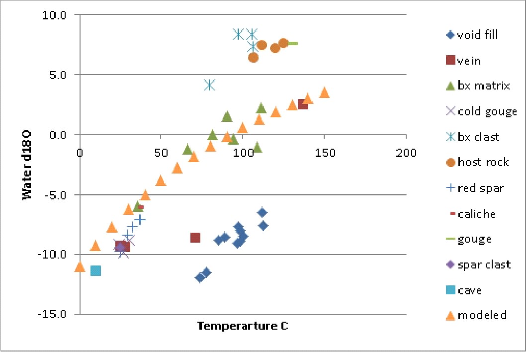
Figure 2. Calculated oxygen isotope temperature of water in equilibrium with sampled minerals, from Swanson et al. (2012) versus temperature for the samples calculated from clumped isotope thermometry (calcite-water fractionation relation of O’Neil et al., 1969). The modeled curve (orange triangles; e.g., Taylor, 1977) is for a mass water/rock ratio of 0.5, a computation that does not account for progressive exchange at varying temperatures along a flow path but which does show that the fluid values can be explained by water-rock interaction and isotope exchange. Many, but not all (for example, the ‘void’ samples), of the vein fluid values reflect involvement of a moderately-exchanged meteoric water that originally had an oxygen isotopic composition of about -11 permil relative to the global standard, Vienna Standard Mean Ocean Water (VSMOW) and exchanged with rock at increasingly higher temperatures. The ‘void’ samples lie along their own exchange path having a higher initial temperature but the same expression of increased isotopic modification with increasing temperature. ‘Host rock’ and ‘breccia clast’ values are from samples collected from below the detachment or derived from rocks that originally lay beneath the detachment, respectively. These rocks probably did not interact with fluid during the faulting episode; their elevated temperatures are remnants of their earlier burial history.
Losh (1997) observed (by means of isotope data from crosscutting veins associated with the fault) and modeled the Mormon Peak Detachment rocks as hosting exchanged meteoric waters during relatively early-stage fault movement, followed by unexchanged meteoric waters that infiltrated the fault late in the fault movement history, presumably reflecting a changeover from intergranular (pore-controlled) to fracture-controlled flow as the fault and associated rocks became increasingly extended and deformed. This conclusion is also consistent with a block slide model for the fault, although the formation of two distinct vein sets (reflecting fracturing followed by calcite precipitation (which typically takes time) followed by another episode of fracturing and precipitation) in a block slide is not consistent with a single, rapid-emplacement model for fault movement. It is possible that calcite precipitation under the unusual conditions of a block slide (as just discussed) may be much more rapid than normal; textures or other evidence indicative of such rapid precipitation must be sought to verify this. Alternatively, portions of the slide may have moved more than once before finally coming to rest. This may be verified by finding a later set of structures (e.g., faults in the hanginwall) crosscutting an earlier set, both formed by the block sliding process.
The combined data suggest that water was present in the Mormon Peak Detachment when it moved. Temperatures were high for the depth, suggesting frictional heating, which the water pressure apparently was not high enough to prevent.
4) Examination of the Palisades slide in Idaho revealed that the finely-ground rock in the base of the fault zone, about 10 cm thick, is overlain by a 30- to 60-cm thick layer of conglomeratic fault rock that strongly resembles rocks within the Mormon Peak Detachment. In thin section, this rock from the Palisades slide fault zone contains rounded clasts that are characteristic of the fluidized fault rocks documented by Anders et al. (2000). These rocks are overlain by faulted and veined dolomites. In contrast, the lower plate contains rounded pebbles and cobbles comprising river gravels that show no evidence of fracturing or faulting beneath the detachment. The Heart Mountain Detachment at White Mountain, Wyoming, in contrast, consists of a dark gray microbreccia that contains abundant (~5 volume %) rounded, concentrically-zoned grains identified by Anders et al (2010) as ‘armored grains’ that grew during the late stages of high-temperature fault movement. Conglomeratic fluid breccias are not present above this zone; rather, it is overlain at White Mountain by marble (formed by metamorphism associated with nearby intrusion of andesitic magma, not directly related to the detachment). Clastic dikes of microbreccia with armored grains are abundant in the hangingwall of the detachment. Upper-plate carbonate units are folded and faulted on a scale of hundreds of meters, whereas the footwall shows no deformation even immediately below the detachment. In geologic terms, the Mormon Peak Detachment more closely resembles the Palisades slide detachment: it has moved similar distances and involves similar rocks. The Heart Mountain Detachment was the site of much greater movement, and appears to have attained higher temperatures.
References Cited
Anders, M. H., Christie-Blick, N., and Walker, C. D., 2006. Distinguishing between rooted and rootless detachments. A case study from the Mormon Mountains of southeastern Nevada: Journal of Geology 114, 645-664.
Anders, M H; Aharonov, E; Walsh, J J. 2000, Stratified granular media beneath large slide blocks: Implications for mode of emplacement; Geology28. 11 (Nov): 971-974
Anders, Mark H; Fouke, Bruce W; Zerkle, Aubrey L; Tavarnelli, Enrico; Alvarez, Walter; et al , 2010, The role of calcining and basal fluidization in the long runout of carbonate slides; an example from the Heart Mountain slide block, Wyoming and Montana, U.S.A.; Journal of Geology118. 6 (November): 577-599.
Anders, M., Schneider, J., Scholz, C., Losh, S., 2013, The intergranular damage zone: The key to distinguishing faults from slides; Jour. of Structural Geology
Axen, G. J., Wernicke, B. P., Skelly, M. F., Taylor, W. J., 1990. Mesozoic and Cenozoic tectonics of the Sevier thrust belt in the Virgin River Valley area, southern Nevada. In: Wernicke, B.P. (Ed.) Basin and Range Extension Tectonics Near the Latitude of Las Vegas, Nevada. Geological Society of America Memoir 176, 123-153.
Bodnar, R (2003) Introduction to aqueous-electrolyte fluid inclusions, In Samson I, Anderson A, Marshall D, eds., Fluid Inclusions: Analysis and Interpretations; Mineral. Assoc. Canada Short Course 32: 81-100
Carpenter, J. A., Carpenter, D. G., 1994. Analysis of Basin-Range and fold-thrust struture, and reinterpretation of the Mormon Peak detachment and similar features as gravity slide systems; southern Nevada southwestern Utah, and northwestern. In: Dobbs, S.W., and Taylor, W.J. (Eds.) Structural and Stratigraphic Investigations and Petroleum Potential of Nevada, with Special Emphasis South of the Railroad Valley Producing Trend. Nevada Petroleum Society Conference Volume II, p. 15-52.
Diehl, S.F., Anderson, R.E., Humprey, J.D., 2010, Fluid flow, solution collapse, and massive dissolution at detachment faults, Mormon Mountains, Nevada. In: Umhoefer, P.J., Beard, L.S. and Lamb, M.A., (Eds.), Miocene Tectonics of the Lake Mead Region, Central Basin and Range. Geological Society of America Special Paper 463, 427-441.
Eiler, J., 2007, “Clumped isotope” geochemistry – The study of naturally-occurring, multiply-substituting isotopologues; Earth Planet. Sci. Lett., v. 262, pp. 309-327
Hauser, E; Potter, C; Hauge, T A; Burgess, S; Burtch, S; et al. 1987, Crustal structure of eastern Nevada from COCORP deep seismic reflection data; Geological Society of America Bulletinv. 99, pp. 833-844.
Losh, S., 1997, Stable isotope and modeling studies of fluid –rock interaction associated with the Snake Range and Mormon Peak Detachment Faults, Nevada: Geol. Soc. Amer. Bull., v. 109, pp. 300-323.
O’Neil, J., Clayton , R., Mayeda, T., 1969, Oxyten isotppe fractionation in divalent metal carbonates; Jour. Chrm. Phys. V., 51, pp. 5547-5558.
Pierce, W. G., 1979. Clastic dikes of Heart Mountain fault breccia, northwest Wyoming, and their significance. U.S. Geological Survey Professional Paper 1133, 1-25.
Pierce, W. G., 1980. The Heart Mountain Break-away fault, northwestern Wyoming. Geological Society of America Bulletin 91, 272-281.
Roedder, E., 1984, Fluid Inclusions; Ribbe, P., ed., Mineralogical Society of America Reviews In Mineralogy, vol. 12, pp. 221-290
Skelly, M., 1987, The geology of the Moapa Peak area, southern Mormon Mountains, Clark and Lincoln Counties, Nevada, M.S. thesis, Northern Arizona University.
Swanson, Erika M; Wernicke, Brian P; Eiler, John M; Losh, Steven. 2012, Temperatures and fluids on faults based on carbonate clumped-isotope thermometry; American Journal of Sciencevol. 312 no. 1: pp. 1-21.
Taylor, H P, Jr. 1977, Water/rock interactions and the origin of H (sub 2) O in granitic batholiths; Journal of the Geological Society of London;vol. 133, pp. 509-558.
Taylor, W., 1984, Superposition of thin-skinned normal faulting on Sevier Orogenic Belt thrusts, northern Mormon Mountains, Lincoln County, Nevada; M.S. thesis, Syracuse University, Syracuse NY
Walker, C., 2008, A gravity slide origin for the Mormon Peak detachment: Re-examining the evidence for extreme extension in the Mormon Mountains, southeastern Nevada, U.S.A.; PhD. Diss., Columbia University,
Walker, C. D., Anders, M. H., and Christie-Blick, N., 2007. Kinematic evidence for downslope movement on the Mormon Peak detachment. Geology. 35, 259-262.
Wernicke, B., Walker, J. D., Beaufait, M. S., 1985. Structural discordance between Neogene detachments and frontal Sevier thrusts, central Mormon Mountains, southern Nevada. Tectonics 4, 213-246.